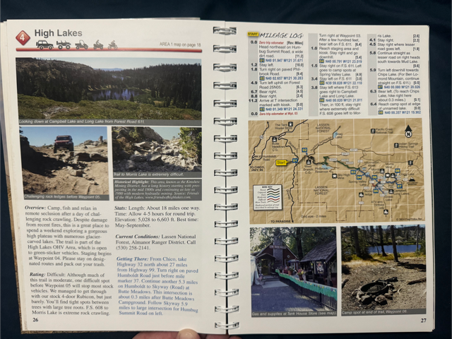
A Week along the Nevada Border
Martin is organizing. Please contact him for additional information or to let him know you are interested.
From Martin:
Dispersed Camping permits catholes. Burn or carry out TP
DAY 1: Travel to Jarbidge, NV (Fuel) or beyond to camp on the way to Jarbidge, NV. Grass Valley to Jarbidge to Elko = 460 miles.
DAY 2: Jarbidge to Elko = 106 miles
DAY 3: Travel to Elko, Nv. Fuel. Camp south of Elko along the Hamilton Stage Route: 40.770698 -115.765828 Approximately 7 hours. Breakup the next two days into 3 days. Decision to be made on the fly.
DAY 4: Pass South Fork Reservoir and follow the BDR route to Tonkin Spring Campground. Approximately 6-7 hours.
DAY 5: Austin,NV Fuel Several Mines in the area. Possible side trip to Mineral Hill NW of RR pass: Nevada Ghost Town - Mineral Hill 40.16056 -116.09805 Follow BDR to Belmont, NV Camp outside Belmont. Approximately 7-8 hours
DAY 6: Side Trip to Manhattan, NV. Then follow BDR to Tonopah – Fuel Perhaps camp near Bass Camp outside Mina, NV. 38.192217 -118.419139 Nevada Ghost Town - Bass Camp
DAY 7: Travel home
Featured Events
Meet at:
Golden Empire Grange
11383 Grange Ct
Grass Valley, CA 95945
Martin is organizing. Please contact him for additional information or to let him know you are interested.
From Martin:
Dispersed Camping permits catholes. Burn or carry out TP
DAY 1: Travel to Jarbidge, NV (Fuel) or beyond to camp on the way to Jarbidge, NV. Grass Valley to Jarbidge to Elko = 460 miles.
DAY 2: Jarbidge to Elko = 106 miles
DAY 3: Travel to Elko, Nv. Fuel. Camp south of Elko along the Hamilton Stage Route: 40.770698 -115.765828 Approximately 7 hours. Breakup the next two days into 3 days. Decision to be made on the fly.
DAY 4: Pass South Fork Reservoir and follow the BDR route to Tonkin Spring Campground. Approximately 6-7 hours.
DAY 5: Austin,NV Fuel Several Mines in the area. Possible side trip to Mineral Hill NW of RR pass: Nevada Ghost Town - Mineral Hill 40.16056 -116.09805 Follow BDR to Belmont, NV Camp outside Belmont. Approximately 7-8 hours
DAY 6: Side Trip to Manhattan, NV. Then follow BDR to Tonopah – Fuel Perhaps camp near Bass Camp outside Mina, NV. 38.192217 -118.419139 Nevada Ghost Town - Bass Camp
DAY 7: Travel home
Meet at:
Golden Empire Grange
11383 Grange Ct
Grass Valley, CA 95945
Gary R will be leading a run to Signal Peak and Mossy Pond on Saturday July 19th., as a pre-run of the Sierra Trek run on August 8th. There will be a sign-up sheet at the next club meeting or contact Gary R.
Meet at the Fordyce Trail Head at 9:30AM and depart by 10:00AM.
Directions to Fordyce Trail Head:
Google Earth - Signal Peak trailhead location (downloads file)
1. I80 East to Eagle Lakes exit (about 1 mile east of I80 and Hwy 20 junction).
2. Turn left at the exit and continue on Eagle Lakes Road about 1/2 mile.
3. Turn right at the Brown Sign (Carlyle Road) for Fordyce Trail and continue about 1/8 mile to the trail head.
Eagle Lakes Road at Indian Springs Campground entrance looking toward brown sign turnoff to trailhead
Turn off from Eagle Lakes Road onto Carlyle Road, heading to Trailhead
Sierra Trek, Signal Peak - Brandy lead
If interested, sign-up sheets at the meetings, or talk to Jim L.
Run will proceed rain or shine.
Meet at the Bambi Inn, Butte Meadows, CA @ 2:00pm 8/15. Leaving for Campbell Lake no later than 2:45pm. Fuel/ some provisions available at the "Tank House" down the road from the Bambi Inn.
We will camp at Butte Meadows, CA area (exact location of camp site: 39.996624, -121.361060)
Trail Details:
Friday
We will leave the Bambi Inn up toward Humbug Summit Road. This is a paved section that will eventually turn to wide, dirt logging roads heading to Philbrook Rd. The road turns back to pavement for a few miles just before Philbrook Reservoir where it will become dirt for the remainder of the journey into camp. After turning up the mountain at the Philbrook Reservoir “Y” the trail becomes more rough, but still easy, logging road until reaching the T-intersection at Lotts Lake. We will air down (if not done so already) at the “T”; this is your last opportunity to make a call out on your cell phone as there is little to no reception from here on. After leaving the “T” the trail becomes a little more difficult with smaller rocks and off camber trail sections until we meet the Spring Valley “Gate-Keeper” (a fairly simple obstacle that keeps the lower slung AWD vehicles out). We will likely make a brief stop after the small creek crossing at Spring Valley Lake then proceed onward. From Spring Valley the trail becomes more rough as we make our way through rock gardens to the top of the ridge and the “Knievel” obstacle. This obstacle should be taken one at a time which will give people an opportunity to act as spotters and to be spotted as they make their way up the hill. After the Knievel overlook we head back down the hill and the trail will ease up as we make our way into the Campbell Lake valley. Hopefully we will make it into camp with plenty of sunlight to gather some firewood and cook dinner.
Saturday
Saturday will likely involve a day trip/ Trail Run to one of the near by features.
-Morris Lake Trail- Short but extremely difficult and technical rock crawling (similar to the winch hills on Fordyce) trail leading down to Morris Lake. Prepare for carnage.
-Mud Lake Trail- Medium difficulty trail to a small lake. Some technical features on the way.
-Ben Lomond Lookout- All day trip (3-5 hours) to the Ben Lomond lookout over looking the towns of Belden and Tobin. A few tricky and tight spots but a pretty easy trail.
-Chips Lake Trail- similar to Mud Lake Trail with one extra obstacle for good measure.
There are lakes near by that can be explored, fished, hiked, or kayaked in and many people bring firearms to shoot for fun. As this is a club run I will leave the decision to bring firearms up to the discretion of individuals choosing to participate, but there will be some firearms present for use as wildlife protection. There is also the option of relaxing in camp all day, which is very fun as well.
Sunday
Sunday will be packing up camp and heading back to the Bambi Inn. Expecting to leave camp by 9:00am with some stops along the way, and a planned potluck lunch (light snacks, sandwiches, etc.) stop at Spring Valley Lake. We should arrive back to the Bambi Inn around 1:00pm.
If anyone owns the book Guide to California Backroads & 4-Wheel-Drive Trails this trail route can be found on page 26-27, trail #4
Meet at:
Golden Empire Grange
11383 Grange Ct
Grass Valley, CA 95945
Meet at:
Golden Empire Grange
11383 Grange Ct
Grass Valley, CA 95945
Topaz Lake; runs to Mt Patterson, Deer Valley, Hope Valley, etc. Jim C/Gary R lead